GIS Work
Most of these projects were made for the courses in the GIS Technician Certificate program in San Diego Mesa College, though some are published works from my undergrad at the University of California, Los Angeles.
GIS Work as a Research Assistant
Southwest Wetlands Interpretive Association | August 2024 – Present
Since completing the GIS Technician Certificate, I have kept working on GIS projects with SWIA as needed. I have kept updating the geodatabases I created during the internship, as well as created maps and other deliverables for the organization’s annual reports.
Keywords: GIS work experience, managing and creating geodatabases, master maps, applied research, data visualization.
Creating Geodatabases and Master Maps for Research Sites and Sampling Methods for Southwest Wetlands Interpretive Association
Mesa College | GISG 270: GIS Work Experience Internship
The goals for this internship was to create geodatabases and master maps of all monitoring sites, including all of the different types of sampling methods and sampling sites, managed by Southwest Wetlands Interpretive Association (SWIA).
During this internship, I learned how to manage deadlines and workloads, creating deliverables with multiple versions, dealing with constant edits and feedback, as well as the pace of a real-world GIS work environment.
Keywords: GIS work experience, managing and creating geodatabases, master maps, applied research, data visualization.
Comparing Endangered Species Richness and Acres of Protected Parks in California State Parks
Mesa College | GISG 111 GIS and Cartography – Final Project
The goal of this project was to create a bi-variate map and implement normalization when appropriate. In this project, I made use of analysis tools such as Dissolve Pairwise, Summary Statistics, and other tools such as Raster to Polygon, Feature Class to Feature Class, and the Intersect tool.
While creating this project, I learned how to normalize data to display results more fairly, as well as learned how to use symbolization to create a better visual-comprehension experience.
Keywords: Chloropleth Map, Endangered Species, Bi-variate Map, Statistics, Data Normalizing
Geodatabase Design for Vegetation Data Sampling
Mesa College | GISG 114 Final Project
The goal for this project is to design and implement a geodatabase on ArcGIS Pro, while correctly using domains and subtypes.
While working on this project, I learned basic geodatabase design principles such as choosing field types, domains, subtypes, coded values, ranges, and defaults.
Keywords: Geodatabase Design, Vegetation Sampling, Field Research, Survey123
Risk of Habitat Loss Due to Sea-Level Rise in the Tijuana Estuary
Mesa College | GISG 112 Spatial Analysis – Final Project
The goal of this project was to create a risk assessment or site-suitability map. In this project, I used analysis tools such as Buffer, Union, Reclassify, Aspect, Slope, Raster Calculator, and other tools like Covert LAS, and LAS to Raster.
While creating this project I learned how to work with LIDAR imagery, how to convert said imagery into rasters, and how to work with raster DEM layers.
Keywords: Risk Assessment, Coastal Salt Marsh, Sea-level Rise, Raster Dataset, LIDAR Imagery, Slope Tool, Aspect Tool, Hydrology Analysis
Canidae Presence in California Least Tern Habitat
Mesa College | GISG 110 Intro to GIS – Final Project
The goal for this project was to create a research poster while utilizing a geoprocessing tool. In this project, I used geoprocessing tools such as Clip, Buffer, and other tools such as Table to Table, and XY Table to Point.
While creating this project, I learned how to use basic geoprocessing tools, how to display X,Y coordinate points on a map, and how to change symbology (this was one of my first projects on ArcGIS Pro).
Keywords: Research Poster, Endangered Species, Habitat Competition, XY Table to Point Tool, Buffer
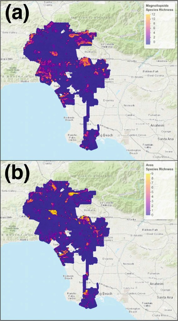
Constructing Ecological Indices for Urban Environments Using Species Distribution Models
UCLA | Institute of Environmental Science – Senior Practicum Project
The goal of the senior practicum project was to create a solution for a partner organization using ArcMap. For my project, our partner organization was the Los Angeles Sanitation Department, who were interested in assessing biodiversity hotspots within the city of Los Angeles. My group and I created ecological indices that display the highest amount of biodiversity based on citizen data (iNaturalist).
While creating this project, I learned much on project management, basics on R coding, data conversion, and writing formal reports and papers with the intention of publishing.
Keywords: Ecological Indices, Species Distribution Modeling, Maxent, Ecological Assessments, Citizen Science
